
Start Arlington Street Directory Search
Use the full Arlington address, including any directional prefix, suffix, and unit, before moving from one source to another. The County’s street directory evidence is strongest when each parcel has its own row of notes. Record the situs address, RPC, legal description, map book and page, recorded owner, and mailing address. That makes it possible to separate a condominium unit from a shared street number and to match the correct deed or permit later.
Street-by-street research is not a direct resident roster. Property data describes a parcel and recorded owner. Maps describe location and surrounding public layers. Recorded deeds describe parties to a transaction. Historical directories can preserve a dated address connection. A lawful voter-list route has separate statutory controls, and the personal Citizen Portal cannot be used as a public street list.
- Enter the normalized address in Arlington Property Search, then capture the parcel keys and both situs and mailing addresses.
- Open the same address in AC Maps, select the normalized result, and pan along the street through address-point and parcel layers.
- Use the property sales tab, deed document identifier, or legal description in the Circuit Court land-record index to trace transfers.
- For voter material, use only the registrar’s controlled statutory access. The Virginia Citizen Portal is a voter’s own verification tool.
- For a past address connection, ask the Charlie Clark Center for Local History about a volume with a street or reverse listing.
Arlington Property Cards by Address
Arlington Property Search is the first address-keyed record for a street directory search. The County assesses local real property annually, and a result can expose the owner, situs address, mailing address, legal description, zoning, class, map book and page, polygon, assessment history, sales, permits, tax-exempt status, and other parcel details. The County says the database updates nightly, but a document-processing delay can still leave a recent change out of view.
The address search is published as the Property Search entry point. Owner appears in a result, but the County’s landing page did not confirm an owner-name search mode. Use the RPC and legal description as the stable match keys. A mailing address is a tax-roll contact address, not proof that the owner or another person occupies the situs parcel.
The Arlington parcel-card example shows the result fields used to begin an Arlington street directory trail.
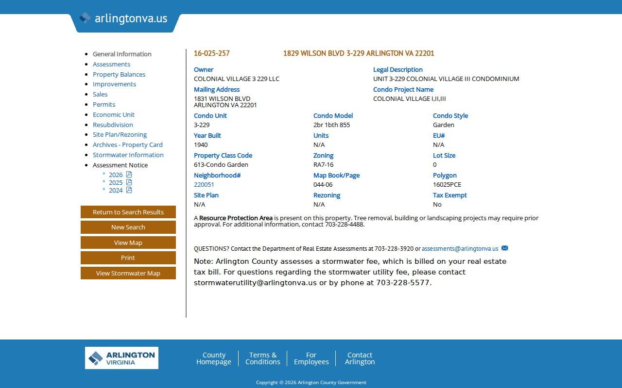
Parcel, legal-description, map-book, and mailing fields let a searcher test whether later records concern the same address.
| Property Search field or tab | How it helps with an address | Limit |
|---|---|---|
| Address | Locates a published property result for a normalized street address and unit. | Exact live search-field labels were not exposed in the official crawl. |
| Owner and mailing address | Shows the recorded tax-roll party and contact address. | Neither field proves physical occupancy. |
| RPC and legal description | Connects a parcel to deeds, plats, sales, and historic research. | Match the description before relying on a name. |
| Sales tab | Shows grantee, sale date, sale code, deed book or page, and document identifier. | A transfer party may be an entity, trustee, or former owner. |
| Permits and archived card tabs | Points toward work history and older property-card material. | Record availability varies by item and processing status. |
Note: Property Search is updated nightly, yet the County warns that the displayed data can lag document processing and is not guaranteed current.
Browse Arlington Streets in AC Maps
AC Maps gives the Arlington street directory its geographic layer. Type the address in the search bar, select a normalized candidate from the left-panel Find Address results, then use pan and zoom to inspect the street segment. The public layers include Address Point, Street Names, parcel or property layers, ZIP Code, voter precincts, polling places, civic associations, zoning and development material. Click adjacent parcels rather than assuming a wide map view defines a legal boundary.
The County’s GIS data is reference information. Its disclaimer says the information may not be accurate, current, or complete and is not a legal record. The map book is compiled from recorded plats, but it is not itself a legal document. Use a recorded plat or deed when a lot line, legal description, or ownership question matters.
Arlington County AC Maps supports the address search and public layers used to move outward along a street.
- Parcel
- A defined piece of real property represented by a County record and map identifier.
- Situs address
- The parcel’s physical address for assessment and geographic reference.
- Plat
- A recorded drawing that depicts lots, subdivisions, and related property details. It controls over a reference map.
- Criss-cross directory
- A reverse directory organized by address or street rather than primarily by a person’s name.
Arlington Street Address Records
An Arlington street directory combines several address-keyed systems, not one database. The assessment card and map establish the parcel. Sales and land records connect legal descriptions to recorded transfers. Permit and code material can document work or a notice at the address. Historic directories provide dated household clues where a volume has the right street section. Each access route has a different record depth and privacy boundary.
| Address-keyed source | Arlington evidence | Access channel |
|---|---|---|
| Property card and sales history | Recorded owner, mailing address, assessment, deed references, permits, and parcel facts | Property Search public web and Real Estate Assessments correction contact |
| AC Maps parcel layers | Address points, adjacent parcels, ZIP, precinct, civic association, zoning, and imagery context | Public AC Maps and County map resources; reference use only |
| Recorded deeds and mortgages | Grantors, grantees, dates, legal descriptions, book or document references | Registered index, paid remote images, free kiosk, counter, or limited mail copies |
| Permit records | Address, permit number, RPC, inspections, plans, conditions, and letters | Permit Arlington portal or Permit Office research kiosk |
| Code Enforcement | Address, notice or order, code issue, and compliance status | Permit Arlington complaint route or 703-228-3232; active detail can be restricted |
| Historic directories and maps | Dated street, address, household, map, and building clues | CCCLH appointment, Washingtoniana, Library of Virginia, and related archives |
The parcel keys are the bridge. A street name can change, a condo can have several records at one number, and a recorded party can differ from an occupant. Record the address evidence in date order so the street directory trail remains clear.
Arlington Deed Chains by Street
Once Property Search supplies a sales-history document identifier or book and page, Arlington Official Records Search can extend the street directory trail through recorded documents. Begin with the current grantee and deed. Transcribe the grantor, grantee, recording date, consideration, and legal description. Then search the earlier grantor as a grantee and compare the same lot, subdivision, condominium unit, or other legal description before stepping backward.
Online index data is free after registration. Images cost $0.50 per page plus a $2 transaction fee, and the County provides full remote access through a paid subscription. When the remote image is unavailable or a deeper history is needed, use the free courthouse kiosk, deed books or microfilm, or a limited mail request for up to five documents with known book and page. Remote access reaches through 1869; earlier Alexandria County material is available through Library of Virginia holdings.
Arlington Circuit Court Land Records explains the registered index, public kiosk, and remote-image options.
Note: A grantor or grantee is a party to a document, not a statement that the person lived at the street address at the time of recording.
Arlington Permit Records by Address
Permit Arlington adds a construction and change-history layer to a street directory search. Its current online system supports applications, plan review, payment, notification, and tracking. The Permit Office research kiosk is the fallback for historic material and can search by address, permit number, or RPC. It can expose permits, inspections, plats, plans, conditions, and letters, with names appearing where a record contains them.
Kiosk files save only to a researcher’s own USB. The kiosk does not email or print records. Permit evidence can help date a change to a parcel, but it does not create a public list of occupants. Code Enforcement uses address information too, though active investigative details are limited and the County asks a complainant for the correct address, details, and best witness time.
Permit Arlington is the online entry point; use the research kiosk when an older address record is not convenient online.
Arlington’s 1935 Street Conversion
A present-day Arlington street directory search can miss an older record because original street names and numbers changed in 1935 after a new naming system was adopted in 1934. The Community Archives preserves the Arlington County Virginia Directory of Street Names from 1935. Search both the old and current form, then use the legal description, map book and page, subdivision, plat, or historic aerial to establish continuity.
The historical jurisdiction name matters too. A pre-1920 record may appear under Alexandria County, and material from 1801 through 1846 can say Alexandria County, District of Columbia. Arlington County was renamed in 1920. The Library of Virginia’s historical county microfilm catalog and the local 1935 address material are the right correction when a street search seems to lose a person or parcel.
The County ZIP map’s block-number table gives one useful local check: South and West sides of numbered streets are even-numbered. It is a map convention, not a substitute for the historic address directory or recorded plat.
Arlington ZIP and Precinct Layers
AC Maps can add ZIP Code, voter-precinct, polling-place, and civic-association layers to an Arlington address search. These layers help orient a parcel, but each has a separate purpose. ZIP is delivery geography, a precinct is election geography, and a civic association boundary is a community boundary. They do not establish a person’s residence or a parcel’s legal boundary.
Arlington’s official ZIP map includes ordinary Arlington ZIPs alongside 22101, 20001, and 20301 boundary or federal areas. USPS should resolve the deliverable ZIP for an exact street and unit. A postal city label can differ from the County context, and the County map should not be used to infer a complete population for an address.
Arlington Historic Street Listings
When the goal shifts to an earlier household, historical directories can add the dated street layer that current parcel records lack. The Charlie Clark Center for Local History holds Hill’s and Polk’s directories from 1924 through 1976 and Haines Arlington directories from 1976 through 1990. Washingtoniana holds Nelson’s directories from 1912 through 1931 and Hill’s Alexandria directories from 1938 through 1955. Old county, telephone, and real-estate directories provide additional paths.
A street section can identify the person or household printed at a number in that edition, but exact local reverse-directory titles and years were not separately listed in the public source material. Ask Center staff for the catalog title and call number. Read the street section and alphabetical entry together, then compare a directory year with deeds, maps, and census material instead of treating the listing as a current result.
Detailed collection years and reading-room access are collected in the Arlington City Directory.
Limits of an Arlington Street Directory
Public address records do not name every person connected to a dwelling. Parcel results show owners and tax mailing addresses. GIS shows geography. Historical directories may show a dated occupant, but they do not cover every address or era. Utility customers, school enrollment, delivery records, private association membership, and many household relationships are not public street-directory fields.
Virginia voter law restricts full voter records, and the public statutory list is not an unrestricted street roster. Protected voters can use address protections, and the Citizen Portal is personal verification rather than a public lookup. DMV data is restricted under the federal Driver’s Privacy Protection Act. A County map or a property card cannot reveal every person near an address.